Tuesday, May 5, 2015

Sandstone Arches

Sandstone arches form as natural bridges due to a variety of environmental factors. Many times they form where cliffs are subject to erosion from the sea or other bodies of water. This erosion gets certain materials out, but researchers have recently discovered that the shape of sandstone arches is actually inherent to the rock itself. A great place to see these arches is at Arches National Park.
For more information see: How Arches Form

Tuesday, April 7, 2015

Community Gardens

Community gardens are popping up around the country as a mechanism for strengthening relationships within communities. Community gardens are essentially just what the name suggests. They are pieces of land that are gardened by a group of people on either private or public land. The gardens may produce fruit or vegetables.
These gardens can take a variety of forms in order to meet the specific needs of the community. For example, an institution like Mercer can offer community gardens to strengthen relationships among Mercerians, as well as with Macon as a whole. Another form is a neighborhood community garden in which individual plots are rented by gardeners. These gardens can be great because they can encourage buying food locally. Buying local food improves both the health and economic status of a community. These community gardens will continue to develop because they can offer numerous benefits to any community!

Thursday, March 19, 2015

My Rock Collection


The objective of this  assignment was to collect and identify 8 rocks. I have identified mine as Andesite, Phyllite, Granite Porphyry, Fault Breccia, Gneiss, Slate, Gabbro, and Granite.

Wednesday, March 4, 2015

Change in Elevation over Distance


I chose to use Macon as my city for this lab. First, I measured out a line of 12 miles that can be seen in red in the above image. I then recorded the elevation for every 2 miles in order to see how the elevation (dependent variable) was affected by the change in distance (independent variable).


Next, I recorded my findings in the above chart. 


Finally, I created a scatterplot of the data in Excel. As you can see, the elevation in Macon was inconsistent and it went up and down over the 12 miles that I recorded.

Saturday, February 14, 2015

Hydrothermal Vents


What are they?
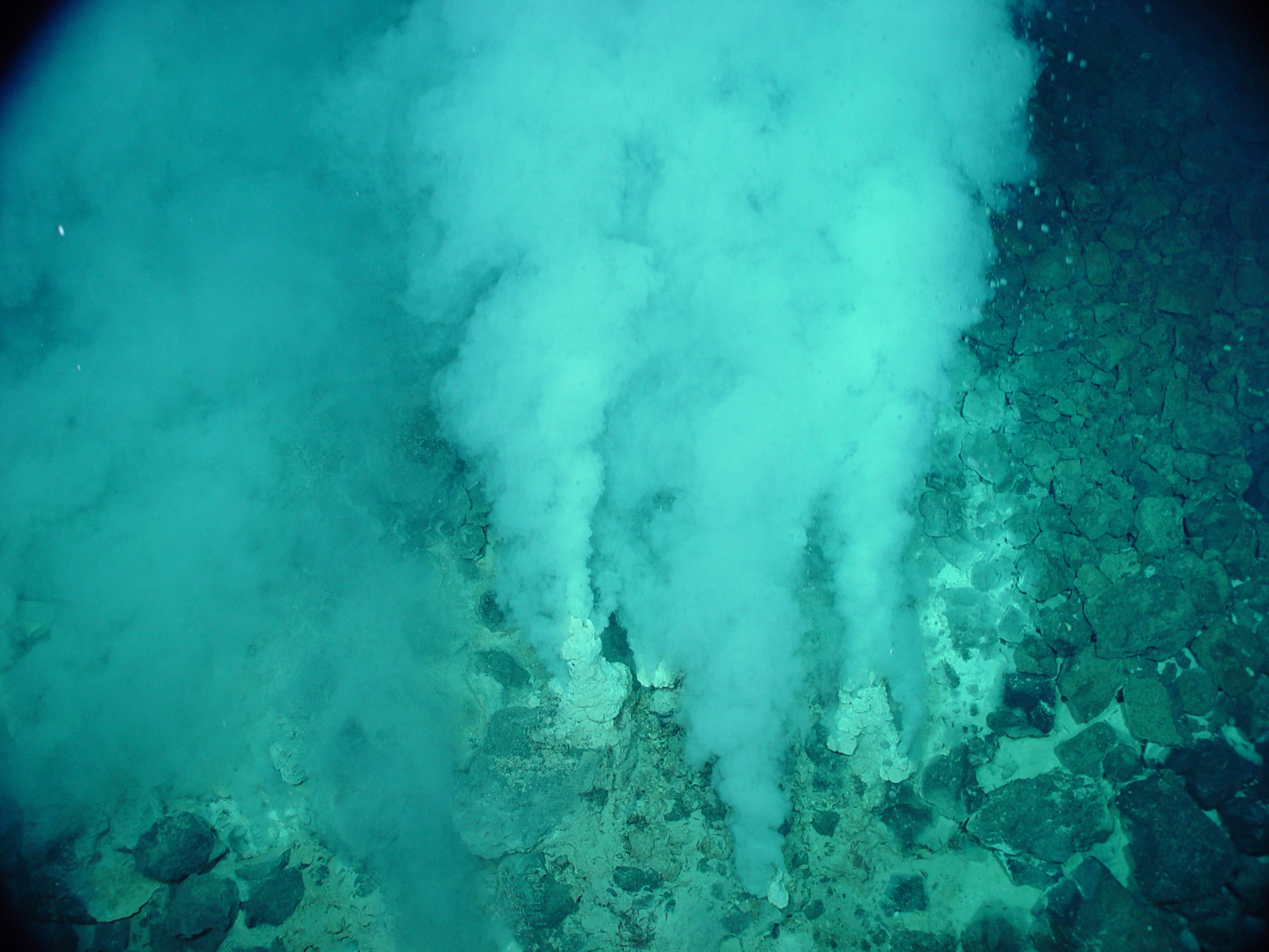
Deep sea hydrothermal vents are fissures in the earth's surface from which geothermally heated water spews. They exist because the earth has so much water on its surface and within its crust.


What is their purpose?
These vents may have been the first site of life on earth. The organisms in the vents use chemosynthesis, or chemical energy, to support life. They are biologically productive and diverse.


Where are they?
These hydrothermal vents were first discovered about 250 miles off the coast of the Galapagos Islands in Pacific Ocean. We now know that they run all over earth through the Atlantic, Indian, and Antarctic Oceans for 42,000 miles.

vent map


What critters can be found there?
Deep sea hydrothermal vents are home to a wide array of unique creatures. Giant tubeworms, or riftia, which bleed like humans  when cut are found numerously. Sulfur bacteria which can duplicate photosynthesis chemically in the dark are also important as they provide a food source for higher organisms.Other organisms include shrimp, crabs, fish, worm, and eels.


Want to Learn More?
Bill Nye

Wednesday, February 11, 2015

Mineral Identification


CALCITE

Calcite is a mineral with a chemical formula of CaCO3. It is extremely common and found throughout the world in all three kinds of rocks. Furthermore, Calcite is the principal mineral of limestone and marble (two of the most common rocks on our planet). 
Calcite's properties make it one of the most widely used minerals. It can be used as a construction material, abrasive, agricultural soil treatment, construction aggregate, pigment, pharmaceutical and more.


More Information


TOPAZ

Topaz is a silicate mineral most often found in igneous rocks Topaz is not an abundant mineral, but it does occur worldwide. It is also a very popular gemstone. Gem quality topaz most commonly occurs in nature as a colorless crystal, but a significant amount of natural topaz also occurs in a color range spanning from yellow to brown. Small amounts of natural blue and pink topaz are also found but rare. Another rare quality of topaz is the matrix which is much desired, since the perfect basal cleavage of Topaz causes it to separate from its base and form loose crystals. 


More Information

Sunday, February 8, 2015

Map Types


Chloropleth map


A chloropeth map is a thematic map in which certain areas are distinctly colored or shaded to represent classed values of a particular phenomenon. They can be used if the data is attached to enumeration units, standardized to show rates or ratios, and there is a continuous statistical surface.

Isarithmic Map


Isarithmic maps represent continuous data by a range of continuous color/value or related classes of color. The data must be continuous or contain data for any possible point within the data set. The boundaries are based on the data and the data type must be quantitative. Examples include continuous temperature or rainfall over a country because any given point within that country will have a temperature or amount of rainfall.


Dot Density Map


A dot density map is a quantitative, thematic map on which dots of the same size are randomly placed in proportion to a numeric attribute associated with an area. Dot density maps convey the intensity of an attribute. Examples of dot density maps include the distribution of car dealerships in Belgium (1 dot = 1 dealership) or earthquake epicenters across the Pacific for the past 10 years (1 dot = 1 epicenter).


Proportional Symbol Map


Proportional symbol maps scale the size of simple symbols (usually a circle or square) proportionally to the data value found at that location The larger the symbol, the "more" of something exists at a location. Examples include liters of coffee consumed per capita in 2010 by country or the location and magnitude of earthquakes in California 1900-2010.